Video highlights from this portion of the trip
Travel stats for travel covered in this blogpost:
Distance: 29.2 Nautical Miles
Time spent traveling: Approx 7.25 hours
Duration: 3 days
Zoomed in map of our travels- Blue indicates our path covered in this blog post
Google Map Locations (click to view on google maps):
Previously, we had just overcome Johnstone Strait on our return home. After a fantastic day sailing down Johnstone we stopped at Shoal Bay due to its proximity to our next objective: rapids.
After a quiet evening at Shoal Bay we took off early in order to time our arrival at several rapids.
We arrived at Dent Rapids a bit early, which provided the opportunity to fly the drone. I'm not sure if the video or pics demonstrate it, but in the area surrounding Dent Rapids, the water is very confused- meaning there's water going in every which direction- boiling up from the deep in all sorts of directions. Boils with heavy current lead to strong eddy lines that will push your boat around. It's exactly like what happens on a river. We didn't expect to use our whitewater skills out here, but being able to read the water and know what it's doing helped a bunch.
You can see the ripples in the water. That disturbance is caused by tidal current being squeezed through small areas, in some cases causing rapids.
Here we are just before entering Dent Rapids- you can see the lines on the water which is "confused water" caused by Dent Rapids
Maya continuing through Dent Rapids
Now, I've said all of that just to say we traversed the rapids fine. Again, it's all about timing your travel through the rapids at slack. Thankfully the next two rapids were close to the first, and we essentially rode the slack tide up, arriving at each rapid as slack arrived.
Those rapids were the last "gates" of the Inside Passage, and by passing those we were pretty much out of the IP. Almost immediately the weather was noticeably warmer and sunnier. We basked in the sun and warmth, steadily making miles to our next anchorage, which was Squirrel Cove.
Sunshine Selfie after passing through three rapids
Boat dog, Disco, loves sunshine!
Panorama enroute to Squirrel Cove
Getting the shot....
...of a giant spider!
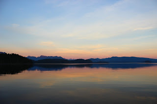
Squirrel cove is basically a little hippie town on the little hippie island of Cortes. We parked the boat right in front of the main part of the town- picking the best spot because, again, we were the only boat anchored there! It's nuts (mind the crappy squirrel pun) how few boats are out cruising at this time of year. The weather was still quite warm and sunny and we soaked it up for all it was worth. Squirrel Cove sits on the west end of Desolation Sound, so it enjoys the same mountain view that can be found in the Desolation Sound anchorages. And what a view! Especially during the incredible sunset we had that night. It was super quiet out and the water was dead flat too, which gave a mirror effect to the water. One of the best sunsets of the trip.
Maya at anchor in Squirrel Cove
Maya at anchor in front of Squirrel Cove
A very calm evening and an amazing sunset at Squirrel Cove
Desolation Sound in the background
Sunset selfie
Disco dog during an amazing sunset
Sunset panorama
Sunset panorama
That's about it for this post. Please check back in soon for the next chapter in our adventure, where we battle fog, wind, and fall storms on our journey back home.
Thanks you for stopping by- we totally appreciate you following along!


No comments:
Post a Comment